

Rail Accessibility Package
Consultation has concluded
If you need any materials in an alternative format or would like to provide feedback in a different way please contact us by emailing yourvoice@westyorks-ca.gov.uk, by calling Metroline on 0113 245 7676, or by writing to FREEPOST WEST YORKSHIRE COMBINED AUTHORITY (no stamp required).
What we hope to do
West Yorkshire Combined Authority is working with Northern Trains (Northern) to make accessibility improvements to rail stations across the region as part of its Access for All programme. Together, we want to make sure customers are safe, can access the information they need and can wait somewhere comfortable with the right facilities.
This work supports our ambition for the Weaver Network, with transport that’s easy to navigate and simple to use. Unveiled in May 2025 by the Combined Authority, the Weaver Network is the new name and unifying brand for transport in West Yorkshire.
The work is due to start in early 2027 at the stations listed below, subject to approval of the business case.
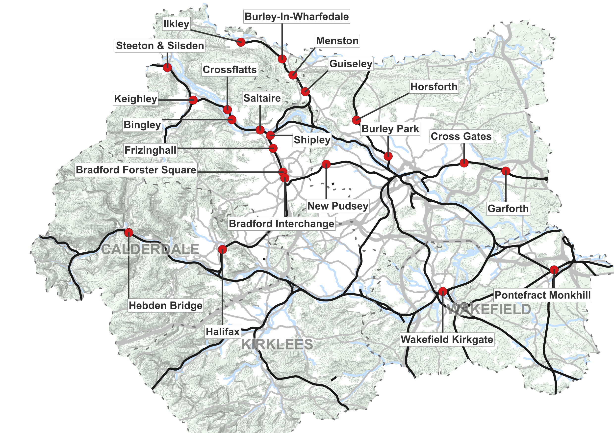
Which stations we plan to improve
Phase one of these improvements includes 22 stations across Bradford, Calderdale, Leeds and Wakefield. You can see which stations are in phase one by:
Viewing the list below
Viewing the map image below
You can also see the stations and what is planned for each station on our interactive map here or on the map image below. Please be aware this function may not be compatible with screen readers. You can see exactly what's happening at each station by clicking here
Stations listed for improvements in phase one | |
|---|---|
Bingley | Hebden Bridge |
Bradford Forster Square | Horsforth |
Bradford Interchange | Ilkley |
Burley in Wharfedale | Keighley |
Burley Park | Menston |
Cross Gates | New Pudsey |
Crossflatts | Pontefract Monkhill |
Frizinghall | Saltaire |
Garforth | Shipley |
Guiseley | Steeton & Silsden |
Halifax | Wakefield Kirkgate |
What accessibility improvements could be installed
The list below shows the types of accessibility improvements to be installed, although these will vary by station. To see exactly what improvement we plan to install at which station, please view the interactive map here or a full list of improvements here
To see what these improvements look like, please see our glossary here
| Accessibility specific improvements |
|---|
Braille Station Maps |
Help Points |
Induction Loops |
Direction signs to lifts, platforms and accessible routes |
Accessible facilities signs |
Handrails with Braille - directions, routes and level changes |
Accessible WC and baby change facilities |
Handrails with Braille - directions, routes and level changes |
Tactile paving - on stairs and ramps |
Tap Rails |
Other improvements |
|---|
Painted lines in car park |
Painted lines on footpaths in car park |
Bike stands |
Anti-slip stair edging |
External pathway improvements |
Seats inside |
Seats outside |
Furniture Painting |
Our project objectives and benefits
Improving accessibility is an important part of improving rail journeys for all existing customers, as well as attracting new ones.
This work aims to:
Make stations accessible and fit for purpose through targeted improvements and replacement of facilities not meeting industry standards.
Encourage more people to travel by rail.
Improve access to jobs, education, leisure and health services.
Improve the customer’s overall journey experience.
How this project is funded
Subject to a successful business case, phase one of the Rail Accessibility Package will be delivered through funding provided to the Combined Authority by HM Government. The funding for this scheme is known as capital funding; this means it can only be spent on schemes to deliver new or improved infrastructure. The cost of phase one (22 stations) is expected to cost £5 million. The subsequent phases covering the remaining 42 stations are expected to be funded by Northern.
The next steps
The Rail Accessibility Package is currently working towards Full Business Case, which will aim to be submitted at the end of 2025.
Works for phase 1 (22 stations) are planned to start early 2027 and be finished by summer 2028. This date may change because it is dependent on the specific approvals processes and the availability of funding.
If you would like to keep informed on updates on this project, please register here to be a part of Your Voice.
-
Glossary
Share Glossary on Facebook Share Glossary on X (formerly Twitter) Share Glossary on Linkedin Email Glossary linkConsultation has concludedType of improvementDefinitionImageBraille Station mapsA map that can be read through touch. The maps have raised areas that represent various features such as buildings and roads, and various forms of raised shading are used to represent land use. Braille is used for labels. Help PointsHelp points enable passengers to speak to a human operator where station staff are unavailable. Typically found on platforms or concourses, these points feature buttons for general assistance and an emergency line.Induction LoopsAlso referred to as Hearing Loops, Audio Frequency Induction Loops or AFILS, it is an audio technology whch supports improved hearing and communication for people with a hearing impairment.Direction signs to lifts, platforms and accessible routesSigns to provide instructions and guidance for navigating the station, acting as a tool for wayfinding that helps people find their way to a destination .Accessible facilities signsSigns to provide instructions to locate accessible facilities like accessible toilets.Accessible WC and baby change facilitiesA specially designed facility that provides space and features for people with disabilities to use the toilet safely. It may include facilities for changing babies.
 Painted lines in car parkPainted lines in car parks typically include clear, high-contrast markings that define parking bays, including dedicated accessible (Blue Badge) parking spaces, pedestrian walkways, crossing zones, and directional arrows for traffic flow.How This Helps:• Accessible Bays: Clearly marked accessible parking spaces (with appropriate width and proximity to station entrances) make it easier for disabled passengers to park and access the station safely.• Visual Clarity: High-contrast markings help people with visual impairments or cognitive disabilities navigate the car park more easily.• Improved Safety: Well-defined pedestrian zones and vehicle lanes reduce the risk of accidents involving vehicles and pedestrians.Painted lines on footpaths in car parkThese are visual guides painted directly onto pedestrian walkways within the car park area, typically showing the path from car park spaces to station entrances or other key facilities.How This Helps:• Wayfinding: Helps all users—especially those with cognitive impairments or visual difficulties—follow a safe, designated route from their vehicle to the station.• Separation from Traffic: Reinforces the division between pedestrian areas and vehicle movement zones, improving safety.• Consistency: Helps create a logical, readable environment that supports those who benefit from predictable visual cues (e.g. people with autism).Bike standsA device to which bicycles can be securely attached for parking purposes. It may be freestanding, or securely attached to the ground or a stationary object, such as a building.
 Handrails with Braille (directions, routes and level changes)A fixed rail for support that incorporates Braille instructions or guidance to navigate the station.
 Tactile paving (on stairs and ramps)Textured, raised ground surfaces designed to provide physical cues to blind and visually impaired people, helping them detect hazards like street crossings, stairs, and platform edges.Anti-slip stair edgingSafety strips on the edge of stairs to prevent slipping.External pathway improvementsUpgrades to the external pedestrian pathways around the station. This could be things like resurfacing uneven paths, installing dropped kerbs, adding tactile paving, improving drainage, widening paths, and ensuring your route is free from obstructions.Seats insideAreas to sit or rest inside.Seats outsideAreas to sit or rest on the platform or other external area.
Furniture PaintingRepainting or sealing furniture like seats to help with weatherproofing and to make the area a nice space to be.Tap RailsA horizontal rail installed at or near ground level for the benefit of visually impaired people. Blind or partially sighted people use a long cane to detect obstacles in their path, and the tapping rail serves as a detectable surface to alert them to the presence of a barrier.

