

Meltham Greenway
This consultation has concluded, thank you to everyone who took part.
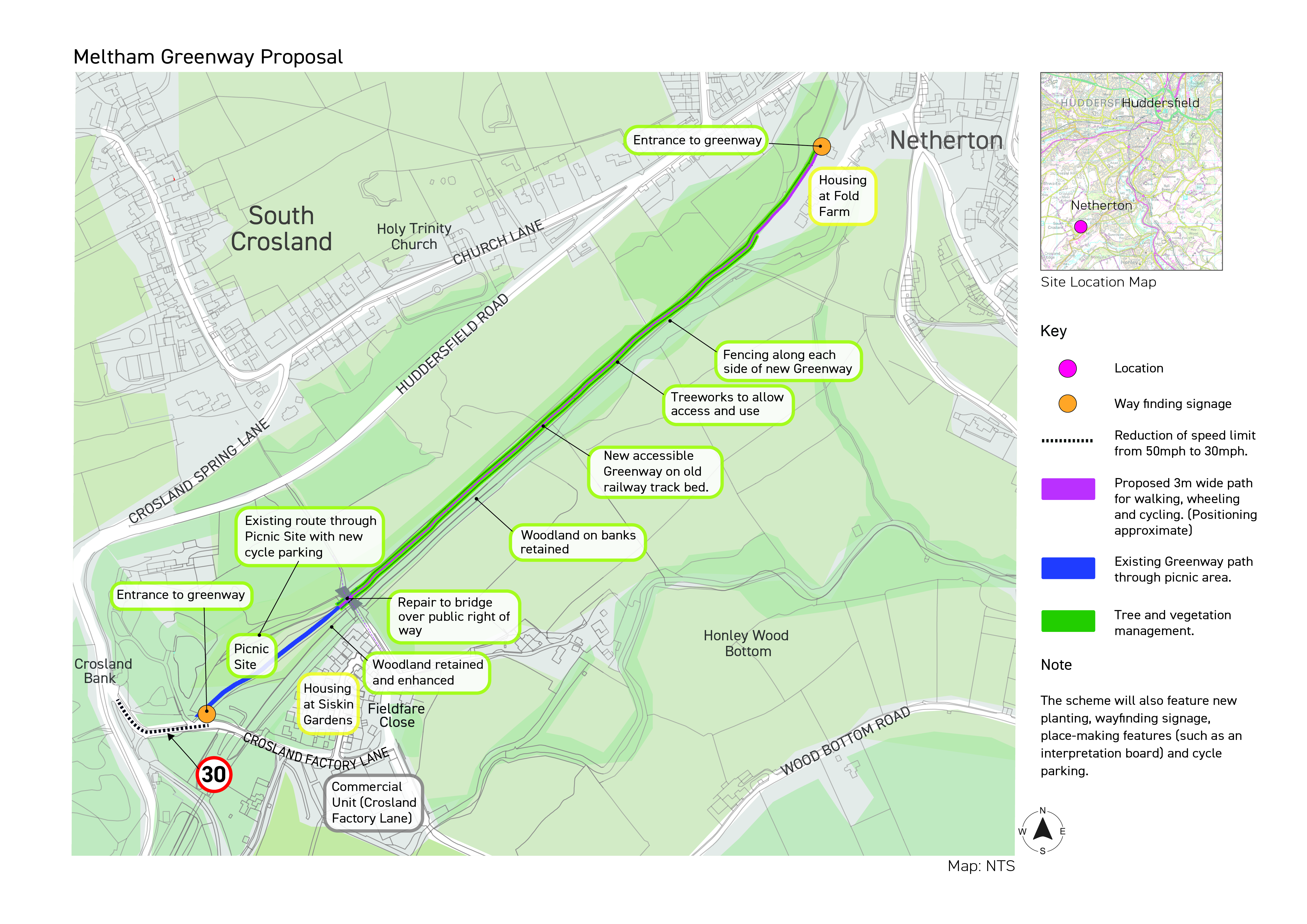
New Meltham Greenway between Crosland Factory Lane picnic site and Fold Farm in Netherton
Project Background
Kirklees Council, in partnership with the West Yorkshire Combined Authority, is working to develop new and improved walking, wheeling and cycling facilities in Netherton.
This exciting project aims to develop a new section of Meltham Greenway, between Crosland Factory Lane picnic site and the Fold Farm housing development (adjacent to Netherton Fold) in Netherton.
We are developing plans to provide a brand new, accessible, traffic-free path that will allow people to connect with nature, enjoy a safer and quiet active journey, live healthier lifestyles, and enhance connectivity.
This project would be the next section of greenway to be developed on the former Meltham branch railway corridor. Existing sections of Meltham Greenway include the traffic-free path between Meltham (Morrisons) and Huddersfield Road, and a short section at the picnic site adjacent to Crosland Factory Lane.
Our Proposals
The proposed new greenway would be provided along the former railway embankment between the existing picnic site at Crosland Factory Lane, and the Fold Farm housing development (adjacent to Netherton Fold) in Netherton.
The project aims to:
- Provide a new, accessible, 755m long path for walking, wheeling and cycling
- Promote the use of active travel through a scenic heritage route
- Improve access to green spaces
- Provide physical and mental health benefits
- Enhance connectivity
The new path is being designed to be fully accessible for wheelchairs, pushchairs and mobility scooters, opening up more of our greenspace to more people. The scheme will also feature new planting, wayfinding signage, place-making features and cycle parking. At the Crosland Factory Lane access point is it intended to improve safety for all by introducing a lower speed limit on the road.
The project will be delivered by Kirklees Council in partnership with the Combined Authority. The funding for this project is from central government and has been ringfenced, so we are only able to spend it on active travel projects like this one.
Tell us what you think
You can get in touch by:
- answering our survey
- asking us a question if there's anything we've missed in our FAQs
- emailing us on yourvoice@westyorks-ca.gov.uk
- writing to us (no stamp needed): FREEPOST West Yorkshire Combined Authority
- calling MetroLine on 0113 245 7676 to ask for a paper survey to be posted to you
Next steps
After the public consultation has closed, your feedback will be analysed and considered as we develop the final designs.
Subject to development of a successful business case and receiving planning approval, we expect construction to start in 2026.
Take our survey by Sunday 9 November 2025 |
This consultation has concluded, thank you to everyone who took part.
Ask us a questions and we'll get back to you as soon as we can. Please note your question and the answer will be published on this page.
