

Huddersfield Rail Station Connections - Second stage consultation
This engagement has now closed, thank you for taking part.
The Outcome Report can be viewed here.
The information and proposals from the consultation can be found below.
To view all updates on this project please visit the Huddersfield Blueprint website.
Kirklees Council, and the West Yorkshire Combined Authority, are proposing to make it easier to walk, cycle or travel by bus between Huddersfield Rail Station and the places you live, learn, work, or visit in the town centre.
In October and November 2021, we asked for your feedback on the initial proposals. Since then, we have considered your feedback and undertaken further review of the designs. We have now made some changes and would like to hear your views on these updated proposals.
How can I get involved?
We recommend you view the plans and read this page first to find out more about the scheme.
- Complete the survey by Friday 23 December to give us your feedback. Free prize draw: For your chance to win one of three 10 Day Saver Bus MCard tickets for ten days of unlimited bus travel in West Yorkshire (via the app) you can opt-in to our free prize draw
- Read our frequently asked questions (FAQs) or ask us a question
- Tell others about this consultation
- Join us at an event:
Drop in events: No need to register – just turn up | ||
Yorkshire Children’s Centre Brian Jackson House, New North Parade, HD1 5JP | Thursday 24 November | 9am - 12pm |
The Media Centre 7 Northumberland Street, HD1 1RL | Monday 28 November | 1pm - 4pm |
St George’s Square Outside Huddersfield Rail Station, HD1 1JB | Wednesday 30 November | 5pm - 8pm |
Online webinars | ||
Tuesday 29 November | 12pm - 1pm | |
Thursday 1 December | 6pm - 7pm | Registration closed |
Background
The Huddersfield Rail Station Connections scheme complements of the wider 10-year Huddersfield Blueprint to help create a thriving, modern-day, family-friendly town centre with better connected, vibrant streets, walking and cycling routes and enhanced public transport.
One of six areas to be regenerated through the Huddersfield Blueprint is ‘The Station Gateway’, with the Grade I listed Huddersfield Rail Station at the heart of this location. In front of the station, St George’s Square is bordered by other historic buildings, including Estate Buildings and The George Hotel, the birthplace of rugby league.
Huddersfield Rail Station Connections will also help prepare for the Transpennine Route Upgrade. Network Rail is investing in the railway running through Huddersfield to Leeds, Manchester and beyond, to improve connectivity and support economic growth in the north.
Scheme aims
The aims of this scheme are to:
- Support increased future rail demand through Huddersfield by improving sustainable station access
- Make it easier for people to choose walking, cycling and bus travel in the town centre rather than car use
- Improve accessibility for people who walk or cycle in and around the centre of Huddersfield
- Create a more people-focused Huddersfield with better public spaces, supporting sustainable economic growth and investment
Which proposals need further consultation?
Options for the following areas were consulted on in 2021 and received mixed support. Further assessments have been carried out and we are now asking for views on the updated proposals in the four areas below.
Area 1a: Northumberland Street
- Wider pavements with trees and sustainable drainage
- Narrower road and lane widths and a new 20 mph speed limit
- Improved crossings for people who walk or cycle
- Bus stop retained
- Pay and display parking changed to loading and disabled parking
See how the changes to Northumberland Street would look here.
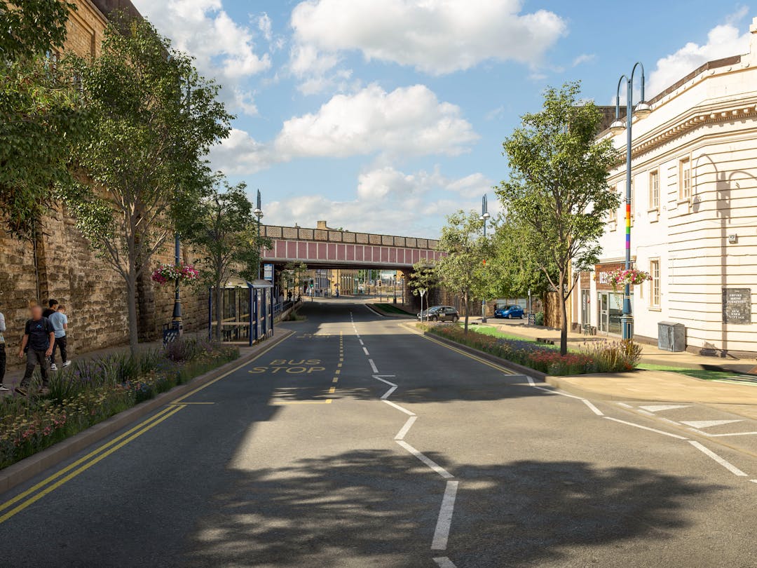
Area 1b: John William Street
- Wider pavements with trees and sustainable drainage
- Central hatching removed to narrow the road, while lane widths stay the same
- 20mph speed limit between Northumberland Street and Brook Street, along Wood Street
- Improved crossings for people who walk or cycle
- Segregated cycle track between Brook Street and Fitzwilliam Street (connecting with Area 2)
- Way-marked quiet cycling route along Wood Street between Northumberland Street and Brook Street
- Bus stops retained and repositioned
- Taxi rank retained
- Some loss of pay and display parking, with new disabled parking
- New loading bays
See how the changes to John William Street would look here.
Area 2: St John’s Road and Oxford Street
- Improved crossing of the ring road for people who walk or cycle
- New crossing of the ring road for people who cycle
- Segregated cycle track between Fitzwilliam Street and Beck Road
See how the changes to the ring road (Castlegate) would look here or Beck Road, just off the ring road, here.
Area 3a: Trinity Street - on-street improvements
- Two-way segregated cycle track along Trinity Street, between New North Parade and Greenhead Road
- Improved and new cycle crossings of the ring road, slip road and Trinity Street
- Improved and new crossings of the ring road and slip roads for people who walk
See how the changes to Trinity Street would look like here.
You can also view Frequently Asked Questions (FAQs) for further information.
We want to hear your views on our revised proposals. Please tell us what you think and complete our survey using the link below.
The consultation closed at 23:59 hours on Friday 23 December 2022.
Contact us and accessibility
If you would like to contact us, or request information in an alternative format, you can:
- Email yourvoice@westyorks-ca.gov.uk
- Phone MetroLine on 0113 245 7676
- Write to FREEPOST CONSULTATION TEAM WYCA
What has happened since the first consultation?
Proposals that were supported during the first consultation, and are progressing to the next design stage are:
- Area 3b: Trinity Street - Underpass Improvements - to complement on-street plans
- Area 4: Brunswick Street Footpath Improvements - including adding a cycle track
- Area 5: Huddersfield Rail Station Entrance Hall - extension of the automatic ticket gate line
- Improving cycling provision on Willow Lane was also supported in the proposals for Area 2: St John’s Road. This is now being progressed as part of the A641 Bradford Road scheme.
Proposals for Area 6: Mobility Hubs were supported, however plans for these have been paused and will be revisited once a new transport strategy has been developed.
Removal of crossings in Area 3c: Trinity Street - Cycle link to Greenhead Park was not supported. An alternative route along Greenhead Road and Park Avenue may be considered as part of a future scheme for the A629 Halifax Road.
Transforming Cities Fund
The scheme is funded by the Transforming Cities Fund (TCF), a major programme of investment from central government which aims to provide more accessible, attractive and cleaner alternatives to car journeys.
Kirklees Council has secured £75m of TCF funding to help ‘level up’ the UK economy and redistribute wealth, jobs, and investment more equitably across England. It forms part of a wider plan to tackle the climate crisis, reduce car journeys and deliver a more sustainable future for the region. Up to £16m is allocated to Huddersfield Rail Station Connections, which forms just one of the transformational schemes to be delivered across Kirklees.
Next steps
We will consider all feedback gathered through this public consultation as we develop the next stage of more detailed design of our proposals.
If you want to be kept informed on the progress of this scheme, please register here: www.yourvoice.westyorks-ca.gov.uk/register

The proposals

Videos


Frequently asked questions (FAQs)
-
 About the scheme
- Why are the changes being proposed?
- What are the aims of the scheme?
- How will the scheme be measured for its success?
- How will these results be delivered?
- How much will the scheme cost?
- Can the money be spent on other priorities?
- What is the status of the current proposals?
- When will the detailed designs become available?
- When will the work start on site?
- When will the work finish on site?
- Will all the proposals be built?
- How does the scheme link to other improvements in the town?
-
Area 1a: Northumberland Street
- Why is the speed limit being reduced to 20mph?
- Why is the width of the road being narrowed?
- Have the needs of disabled users been considered?
- Why is the pavement being widened along the south side?
- What are the benefits of sustainable drainage?
- How would the proposals affect bus users?
- How might private vehicles be impacted?
- Would there be any changes to parking?
- Would deliveries be affected?
-
Area 1b: John William Street
- Why is the speed limit being reduced to 20mph?
- Why is the width of the road being narrowed?
- Have the needs of disabled users been considered?
- Why are you widening the pavement along both sides?
- What are the benefits of sustainable drainage?
- What provision is planned for people who cycle?
- How would the proposals affect bus users?
- Would the taxi rank be retained?
- What would be the impact on parking?
- Would deliveries be affected?
-
Area 2: St John’s Road and Oxford Street
- How would the proposals benefit people who walk?
- Have the needs of disabled users been considered?
- What improvements would be made for people cycling?
- Why are no cycling facilities proposed further along St John’s Road?
- Would bus users be impacted?
- Would the proposals affect other road users?
- Would there be any impact on trees and landscaping?
- Does any land and property need to be acquired?
-
Area 3a: Trinity Street - on-street improvements
- How would the proposals improve provision for people cycling?
- How would people who are cycling reach Greenhead College and Greenhead Park?
- How would the proposals affect people who walk?
- Have the needs of disabled users been considered?
- Why is the underpass also proposed for an upgrade?
- How would the proposals impact other road users?
-
About the Transforming Cities Fund
- What benefits will the TCF programme bring?
- What is the Transforming Cities Fund (TCF) programme?
- What will be delivered through the TCF programme?
- Which organisations are involved?
- What benefits will the TCF programme bring?
- How is the TCF programme funded?
- Why is this work important? / Why is this money being spent on TCF at this time?
- Who will benefit?
- When do projects get underway?
- When will the programme of works be completed?
- How is the programme impacted by COVID-19?
- As part of West Yorkshire’s devolution deal, £317 million was secured to deliver the Leeds City Region TCF programme but it will cost more than this to deliver the schemes outlined in the bid. What does this mean?
- How does TCF complement other transport infrastructure schemes being delivered across the region?
- Where can I find out more information?
- How can I have my say on schemes in my area?
- How was the bid developed?
- Who was the bid developed with?
- How were decisions made around which schemes to include in the bid?
Who's listening
-

-
ES
Webinar
-
Recording of the Huddersfield Rail Station Connections webinar on 29 November 2022