Major Transport Improvements A629 Halifax to Huddersfield
This engagement has now closed, thank you for taking part.
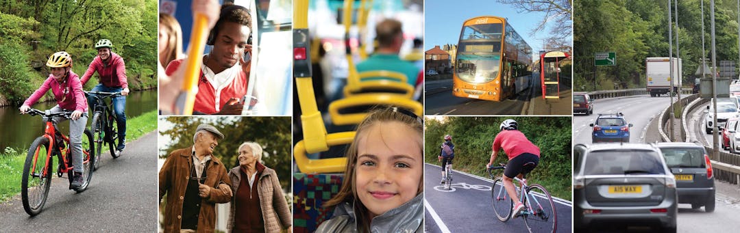
Calderdale Council, Kirklees Council and the West Yorkshire Combined Authority are developing a series of improvements along the A629 route from Halifax to Huddersfield and we want to know what the key issues are for you as users of the route.
The aim of this scheme is to provide improved accessibility to Halifax and Huddersfield by improving walking, cycling and bus travel along the route.
The project includes:
- creation and improvement of cycle routes to Halifax and Huddersfield, better linking to key trip attractors, such as Calderdale and Kirklees hospitals, Halifax and Elland rail stations, and Elland, Huddersfield and Halifax town centres
- off network green ways and on highway cycle infrastructure
- creating a quality bus corridor with highway measures to improve bus journey times and journey quality
- real time information along bus routes, with improved stop locations
- bus infrastructure that can make it possible for bus operators to introduce an express service between Huddersfield and Halifax
- active network management to improve all journey modes
- reducing congestion at West Vale through capacity and junction signal improvements
By delivering the proposed improvements, we aim to achieve:
- Economic growth: The project will improve access to Halifax and Huddersfield from the M62, encouraging investment and enabling access to land for housing and employment developments in Calderdale and Kirklees.
- Sustainability: The bus corridor will make bus journeys more practical, encouraging more people to use the service. Significant cycling and pedestrian improvements will make these actives modes more popular for leisure and commuting.
- Safety: Dedicated cycle and pedestrian routes will make for safer journeys.
- Journey times: Reduced congestion due to an increase in the use of sustainable travel modes and a reduction in private vehicle use along the route will lead to improved journey times.
- Cleaner environment: The investment in active travel infrastructure and public transport will encourage users to reduce private vehicle usage and use sustainable travel modes, leading to fewer emissions and reduced congestion.
To help you understand the proposed project, the scheme has been split into five sections as follows:
- Section A: Halifax to Calder Hebble junction
- Section B: Elland and West Vale
- Section C: Ainley Top
- Section D: Ainley Top to Edgerton
- Section E: Edgerton to Huddersfield Town Centre

More details on the scheme and each of these sections, including maps and diagrams can be found using the link above or on display at one of our public drop-in events as listed below:
| Date | Time | Location |
| Monday 11th February | 3pm - 7pm | Cedar Court Hotel, Ainley Top, HD3 3RH |
| Monday 18th February | 3pm - 7pm | Southgate Methodist Church, Elland, HX5 0JL |
| Monday 25th February | 3pm - 7pm | Gledholt Methodist Church, Marsh, HD1 5QX |
| Wednesday 27th February | 3pm - 7pm | Huddersfield Town Hall, HD1 2TA |
| Tuesday 5th March | 3pm - 7pm | Halifax Town Hall, HX1 1UJ |
Calderdale Council, Kirklees Council and the West Yorkshire Combined Authority are developing a series of improvements along the A629 route from Halifax to Huddersfield and we want to know what the key issues are for you as users of the route.
The aim of this scheme is to provide improved accessibility to Halifax and Huddersfield by improving walking, cycling and bus travel along the route.
The project includes:
- creation and improvement of cycle routes to Halifax and Huddersfield, better linking to key trip attractors, such as Calderdale and Kirklees hospitals, Halifax and Elland rail stations, and Elland, Huddersfield and Halifax town centres
- off network green ways and on highway cycle infrastructure
- creating a quality bus corridor with highway measures to improve bus journey times and journey quality
- real time information along bus routes, with improved stop locations
- bus infrastructure that can make it possible for bus operators to introduce an express service between Huddersfield and Halifax
- active network management to improve all journey modes
- reducing congestion at West Vale through capacity and junction signal improvements
By delivering the proposed improvements, we aim to achieve:
- Economic growth: The project will improve access to Halifax and Huddersfield from the M62, encouraging investment and enabling access to land for housing and employment developments in Calderdale and Kirklees.
- Sustainability: The bus corridor will make bus journeys more practical, encouraging more people to use the service. Significant cycling and pedestrian improvements will make these actives modes more popular for leisure and commuting.
- Safety: Dedicated cycle and pedestrian routes will make for safer journeys.
- Journey times: Reduced congestion due to an increase in the use of sustainable travel modes and a reduction in private vehicle use along the route will lead to improved journey times.
- Cleaner environment: The investment in active travel infrastructure and public transport will encourage users to reduce private vehicle usage and use sustainable travel modes, leading to fewer emissions and reduced congestion.
To help you understand the proposed project, the scheme has been split into five sections as follows:
- Section A: Halifax to Calder Hebble junction
- Section B: Elland and West Vale
- Section C: Ainley Top
- Section D: Ainley Top to Edgerton
- Section E: Edgerton to Huddersfield Town Centre
More details on the scheme and each of these sections, including maps and diagrams can be found using the link above or on display at one of our public drop-in events as listed below:
| Date | Time | Location |
| Monday 11th February | 3pm - 7pm | Cedar Court Hotel, Ainley Top, HD3 3RH |
| Monday 18th February | 3pm - 7pm | Southgate Methodist Church, Elland, HX5 0JL |
| Monday 25th February | 3pm - 7pm | Gledholt Methodist Church, Marsh, HD1 5QX |
| Wednesday 27th February | 3pm - 7pm | Huddersfield Town Hall, HD1 2TA |
| Tuesday 5th March | 3pm - 7pm | Halifax Town Hall, HX1 1UJ |
This engagement has now closed, thank you for taking part.
Do you have a question for us? Check out the FAQ section above or ask us here!
-
Share I'd like to state my opposition to bus stops being removed on Jepson Lane, Elland. I'm not sure which ones have been earmarked exactly but all need to stay. I live at the very top of Park Ave and already have a walk of 200/250 yards to the nearest bus stop. People come from every direction to catch buses on Jepson Lane, some from a much further distance than me so I don't see who is going to benefit from their removal. Buses don't stop at both bus stops every time on their journey to Halifax or Huddersfield so I don't see that this extends the journey time unnecessarily. Each day there is a massive amount of schoolchildren arriving at both bus stops towards Halifax from Brooksbank School, to remove one of these would cause a bottleneck at one of the stops. It can be quite intimidating for members of the public being in the middle of a large group of schoolchildren. We should be increasing bus stops not removing them, you are only giving people more reasons to stop catching the bus. on Facebook Share I'd like to state my opposition to bus stops being removed on Jepson Lane, Elland. I'm not sure which ones have been earmarked exactly but all need to stay. I live at the very top of Park Ave and already have a walk of 200/250 yards to the nearest bus stop. People come from every direction to catch buses on Jepson Lane, some from a much further distance than me so I don't see who is going to benefit from their removal. Buses don't stop at both bus stops every time on their journey to Halifax or Huddersfield so I don't see that this extends the journey time unnecessarily. Each day there is a massive amount of schoolchildren arriving at both bus stops towards Halifax from Brooksbank School, to remove one of these would cause a bottleneck at one of the stops. It can be quite intimidating for members of the public being in the middle of a large group of schoolchildren. We should be increasing bus stops not removing them, you are only giving people more reasons to stop catching the bus. on Twitter Share I'd like to state my opposition to bus stops being removed on Jepson Lane, Elland. I'm not sure which ones have been earmarked exactly but all need to stay. I live at the very top of Park Ave and already have a walk of 200/250 yards to the nearest bus stop. People come from every direction to catch buses on Jepson Lane, some from a much further distance than me so I don't see who is going to benefit from their removal. Buses don't stop at both bus stops every time on their journey to Halifax or Huddersfield so I don't see that this extends the journey time unnecessarily. Each day there is a massive amount of schoolchildren arriving at both bus stops towards Halifax from Brooksbank School, to remove one of these would cause a bottleneck at one of the stops. It can be quite intimidating for members of the public being in the middle of a large group of schoolchildren. We should be increasing bus stops not removing them, you are only giving people more reasons to stop catching the bus. on Linkedin Email I'd like to state my opposition to bus stops being removed on Jepson Lane, Elland. I'm not sure which ones have been earmarked exactly but all need to stay. I live at the very top of Park Ave and already have a walk of 200/250 yards to the nearest bus stop. People come from every direction to catch buses on Jepson Lane, some from a much further distance than me so I don't see who is going to benefit from their removal. Buses don't stop at both bus stops every time on their journey to Halifax or Huddersfield so I don't see that this extends the journey time unnecessarily. Each day there is a massive amount of schoolchildren arriving at both bus stops towards Halifax from Brooksbank School, to remove one of these would cause a bottleneck at one of the stops. It can be quite intimidating for members of the public being in the middle of a large group of schoolchildren. We should be increasing bus stops not removing them, you are only giving people more reasons to stop catching the bus. link
I'd like to state my opposition to bus stops being removed on Jepson Lane, Elland. I'm not sure which ones have been earmarked exactly but all need to stay. I live at the very top of Park Ave and already have a walk of 200/250 yards to the nearest bus stop. People come from every direction to catch buses on Jepson Lane, some from a much further distance than me so I don't see who is going to benefit from their removal. Buses don't stop at both bus stops every time on their journey to Halifax or Huddersfield so I don't see that this extends the journey time unnecessarily. Each day there is a massive amount of schoolchildren arriving at both bus stops towards Halifax from Brooksbank School, to remove one of these would cause a bottleneck at one of the stops. It can be quite intimidating for members of the public being in the middle of a large group of schoolchildren. We should be increasing bus stops not removing them, you are only giving people more reasons to stop catching the bus.
EllandLass asked almost 7 years agoThanks for your message and suggestion. We've proposed the removal of one bus stop on each side of the road to help traffic flow in this congested area of Elland. We've captured your concern and we will include in our analysis of this consultation and will keep you up to date with progress on this.
-
Share There are some specific problems to overcome on the Thornhill Road and Occupation Road sections (in Kirklees) The area has a high demand for daytime parking predominantly because of its proximity to HRI. Is there a proactive active policy to encourage more hospital employees to cycle, walk or bus to work rather than use their car? Both Thornhill Road and Occupation Road need to be subject to 20mph speeds limits and cycle lanes need to be wide and mandatory. Has the possibility of using armadillos or other forms of segregation been considered. (Arrmadillos work well in Tavistock Street in London). Allowing parking on Occupation Road will not allow space for cyclists on both sides of the road. In The Netherlands motor vehicles are described as "guests" on the "quiet ways". Is this principle going to be adopted here. so that, for example, if a motor vehicle wishes to use Occupation road they will be aware of their status and will have to drive accordingly. In reality it can only be a 20mph one-way route for them with no overtaking between Thornhill Road and Lindley. Is this principle accepted in the plan? The Priority rules at the junction of Thornhill Road and Occupation Road are ambiguous and, therefore, potentially dangerous. Traffic going north along Thornhill Road, and entering Occupation Road, cross a broken line on Thornhill Road and enter a slip road across the bottom of Saville Road but there are no road markings beyond this. It means that traffic entering Occupation Road via Thornhill Road from another direction can potentially meet another vehicle at the next junction without either vehicle knowing who has right of way. Are there plans to resolve this problem so that the cyclist has a safe route at this junction? on Facebook Share There are some specific problems to overcome on the Thornhill Road and Occupation Road sections (in Kirklees) The area has a high demand for daytime parking predominantly because of its proximity to HRI. Is there a proactive active policy to encourage more hospital employees to cycle, walk or bus to work rather than use their car? Both Thornhill Road and Occupation Road need to be subject to 20mph speeds limits and cycle lanes need to be wide and mandatory. Has the possibility of using armadillos or other forms of segregation been considered. (Arrmadillos work well in Tavistock Street in London). Allowing parking on Occupation Road will not allow space for cyclists on both sides of the road. In The Netherlands motor vehicles are described as "guests" on the "quiet ways". Is this principle going to be adopted here. so that, for example, if a motor vehicle wishes to use Occupation road they will be aware of their status and will have to drive accordingly. In reality it can only be a 20mph one-way route for them with no overtaking between Thornhill Road and Lindley. Is this principle accepted in the plan? The Priority rules at the junction of Thornhill Road and Occupation Road are ambiguous and, therefore, potentially dangerous. Traffic going north along Thornhill Road, and entering Occupation Road, cross a broken line on Thornhill Road and enter a slip road across the bottom of Saville Road but there are no road markings beyond this. It means that traffic entering Occupation Road via Thornhill Road from another direction can potentially meet another vehicle at the next junction without either vehicle knowing who has right of way. Are there plans to resolve this problem so that the cyclist has a safe route at this junction? on Twitter Share There are some specific problems to overcome on the Thornhill Road and Occupation Road sections (in Kirklees) The area has a high demand for daytime parking predominantly because of its proximity to HRI. Is there a proactive active policy to encourage more hospital employees to cycle, walk or bus to work rather than use their car? Both Thornhill Road and Occupation Road need to be subject to 20mph speeds limits and cycle lanes need to be wide and mandatory. Has the possibility of using armadillos or other forms of segregation been considered. (Arrmadillos work well in Tavistock Street in London). Allowing parking on Occupation Road will not allow space for cyclists on both sides of the road. In The Netherlands motor vehicles are described as "guests" on the "quiet ways". Is this principle going to be adopted here. so that, for example, if a motor vehicle wishes to use Occupation road they will be aware of their status and will have to drive accordingly. In reality it can only be a 20mph one-way route for them with no overtaking between Thornhill Road and Lindley. Is this principle accepted in the plan? The Priority rules at the junction of Thornhill Road and Occupation Road are ambiguous and, therefore, potentially dangerous. Traffic going north along Thornhill Road, and entering Occupation Road, cross a broken line on Thornhill Road and enter a slip road across the bottom of Saville Road but there are no road markings beyond this. It means that traffic entering Occupation Road via Thornhill Road from another direction can potentially meet another vehicle at the next junction without either vehicle knowing who has right of way. Are there plans to resolve this problem so that the cyclist has a safe route at this junction? on Linkedin Email There are some specific problems to overcome on the Thornhill Road and Occupation Road sections (in Kirklees) The area has a high demand for daytime parking predominantly because of its proximity to HRI. Is there a proactive active policy to encourage more hospital employees to cycle, walk or bus to work rather than use their car? Both Thornhill Road and Occupation Road need to be subject to 20mph speeds limits and cycle lanes need to be wide and mandatory. Has the possibility of using armadillos or other forms of segregation been considered. (Arrmadillos work well in Tavistock Street in London). Allowing parking on Occupation Road will not allow space for cyclists on both sides of the road. In The Netherlands motor vehicles are described as "guests" on the "quiet ways". Is this principle going to be adopted here. so that, for example, if a motor vehicle wishes to use Occupation road they will be aware of their status and will have to drive accordingly. In reality it can only be a 20mph one-way route for them with no overtaking between Thornhill Road and Lindley. Is this principle accepted in the plan? The Priority rules at the junction of Thornhill Road and Occupation Road are ambiguous and, therefore, potentially dangerous. Traffic going north along Thornhill Road, and entering Occupation Road, cross a broken line on Thornhill Road and enter a slip road across the bottom of Saville Road but there are no road markings beyond this. It means that traffic entering Occupation Road via Thornhill Road from another direction can potentially meet another vehicle at the next junction without either vehicle knowing who has right of way. Are there plans to resolve this problem so that the cyclist has a safe route at this junction? link
There are some specific problems to overcome on the Thornhill Road and Occupation Road sections (in Kirklees) The area has a high demand for daytime parking predominantly because of its proximity to HRI. Is there a proactive active policy to encourage more hospital employees to cycle, walk or bus to work rather than use their car? Both Thornhill Road and Occupation Road need to be subject to 20mph speeds limits and cycle lanes need to be wide and mandatory. Has the possibility of using armadillos or other forms of segregation been considered. (Arrmadillos work well in Tavistock Street in London). Allowing parking on Occupation Road will not allow space for cyclists on both sides of the road. In The Netherlands motor vehicles are described as "guests" on the "quiet ways". Is this principle going to be adopted here. so that, for example, if a motor vehicle wishes to use Occupation road they will be aware of their status and will have to drive accordingly. In reality it can only be a 20mph one-way route for them with no overtaking between Thornhill Road and Lindley. Is this principle accepted in the plan? The Priority rules at the junction of Thornhill Road and Occupation Road are ambiguous and, therefore, potentially dangerous. Traffic going north along Thornhill Road, and entering Occupation Road, cross a broken line on Thornhill Road and enter a slip road across the bottom of Saville Road but there are no road markings beyond this. It means that traffic entering Occupation Road via Thornhill Road from another direction can potentially meet another vehicle at the next junction without either vehicle knowing who has right of way. Are there plans to resolve this problem so that the cyclist has a safe route at this junction?
JDL asked almost 7 years agoHi there, thanks for your comments. I've addressed these below, however your suggestion for a 20mph zone will be recorded and included in our engagement report. We'll keep you up to date with our plans as they progress.
Our proposals are currently at an early design stage and the impact to parking on Occupation Road has not yet been assessed. For cyclists on Occupation Road we will be introducing a 2 metre contra-flow cycle lane southbound and northbound cyclists will cycle on the highway. You'll see this in on Section D of our drawings.
We are stopping up Savile Road so there will no longer be an issue at the junction regarding the right of way for traffic. We are also introducing a cycle lanes northbound and southbound on Thornhill Road.
-
Share Why can we not have a slip road from Park Road (by Cromwell House ) onto Lowfields taking large lorries and such like away from the houses. This was promised years ago by a Labour councillor. on Facebook Share Why can we not have a slip road from Park Road (by Cromwell House ) onto Lowfields taking large lorries and such like away from the houses. This was promised years ago by a Labour councillor. on Twitter Share Why can we not have a slip road from Park Road (by Cromwell House ) onto Lowfields taking large lorries and such like away from the houses. This was promised years ago by a Labour councillor. on Linkedin Email Why can we not have a slip road from Park Road (by Cromwell House ) onto Lowfields taking large lorries and such like away from the houses. This was promised years ago by a Labour councillor. link
Why can we not have a slip road from Park Road (by Cromwell House ) onto Lowfields taking large lorries and such like away from the houses. This was promised years ago by a Labour councillor.
Sheila asked almost 7 years agoThanks for your message and suggestion. This doesn't fit into the scope of this project, which aims to improve journeys between Halifax and Huddersfield for all users, with a focus on improving pedestrian and cyclist journeys.
-
Share Reiterating the question posted by Anna Semlyen.... As a campaigner for 20mph, in the Birkby area, this is a perfect opportunity to push forward and ensure the residential roads that surround the A629, which have plenty of schools, businesses, and other public buildings, let alone the general public living along them, are safer for people and the community as a whole. The council have so far refused to take forward other requests for 20mph limits, due to other priorities, and of course cost. But, now there is plenty of money fir this project, of which a partial amount could be used to bring Kirklees in line with its neighbouring Calderdale borough, and many other regional councils. Kirklees will be left in the dark ages of it doesn’t modernise, and take this great opportunity. on Facebook Share Reiterating the question posted by Anna Semlyen.... As a campaigner for 20mph, in the Birkby area, this is a perfect opportunity to push forward and ensure the residential roads that surround the A629, which have plenty of schools, businesses, and other public buildings, let alone the general public living along them, are safer for people and the community as a whole. The council have so far refused to take forward other requests for 20mph limits, due to other priorities, and of course cost. But, now there is plenty of money fir this project, of which a partial amount could be used to bring Kirklees in line with its neighbouring Calderdale borough, and many other regional councils. Kirklees will be left in the dark ages of it doesn’t modernise, and take this great opportunity. on Twitter Share Reiterating the question posted by Anna Semlyen.... As a campaigner for 20mph, in the Birkby area, this is a perfect opportunity to push forward and ensure the residential roads that surround the A629, which have plenty of schools, businesses, and other public buildings, let alone the general public living along them, are safer for people and the community as a whole. The council have so far refused to take forward other requests for 20mph limits, due to other priorities, and of course cost. But, now there is plenty of money fir this project, of which a partial amount could be used to bring Kirklees in line with its neighbouring Calderdale borough, and many other regional councils. Kirklees will be left in the dark ages of it doesn’t modernise, and take this great opportunity. on Linkedin Email Reiterating the question posted by Anna Semlyen.... As a campaigner for 20mph, in the Birkby area, this is a perfect opportunity to push forward and ensure the residential roads that surround the A629, which have plenty of schools, businesses, and other public buildings, let alone the general public living along them, are safer for people and the community as a whole. The council have so far refused to take forward other requests for 20mph limits, due to other priorities, and of course cost. But, now there is plenty of money fir this project, of which a partial amount could be used to bring Kirklees in line with its neighbouring Calderdale borough, and many other regional councils. Kirklees will be left in the dark ages of it doesn’t modernise, and take this great opportunity. link
Reiterating the question posted by Anna Semlyen.... As a campaigner for 20mph, in the Birkby area, this is a perfect opportunity to push forward and ensure the residential roads that surround the A629, which have plenty of schools, businesses, and other public buildings, let alone the general public living along them, are safer for people and the community as a whole. The council have so far refused to take forward other requests for 20mph limits, due to other priorities, and of course cost. But, now there is plenty of money fir this project, of which a partial amount could be used to bring Kirklees in line with its neighbouring Calderdale borough, and many other regional councils. Kirklees will be left in the dark ages of it doesn’t modernise, and take this great opportunity.
J Johnson asked almost 7 years agoThanks for your message and suggestion. We've captured your feedback; we will include in our analysis of this consultation and will keep you up to date with progress on this.
-
Share I have already returned a paper feedback form, but I omitted to suggest that the introduction of 20 mph zones in residential streets along the planned route through Huddersfield would be beneficial. This should be included in the plan. on Facebook Share I have already returned a paper feedback form, but I omitted to suggest that the introduction of 20 mph zones in residential streets along the planned route through Huddersfield would be beneficial. This should be included in the plan. on Twitter Share I have already returned a paper feedback form, but I omitted to suggest that the introduction of 20 mph zones in residential streets along the planned route through Huddersfield would be beneficial. This should be included in the plan. on Linkedin Email I have already returned a paper feedback form, but I omitted to suggest that the introduction of 20 mph zones in residential streets along the planned route through Huddersfield would be beneficial. This should be included in the plan. link
I have already returned a paper feedback form, but I omitted to suggest that the introduction of 20 mph zones in residential streets along the planned route through Huddersfield would be beneficial. This should be included in the plan.
Mark Davies asked almost 7 years agoThanks for your message and suggestion. We've captured your feedback; we will include in our analysis of this consultation and will keep you up to date with progress on this.
Thanks for your message and suggestion. We've captured your feedback; we will include in our analysis of this consultation and will keep you up to date with progress on this.Thanks for your message and suggestion. We've captured your feedback; we will include in our analysis of this consultation and will keep you up to date with progress on this. -
Share The A629 is considered too narrow to accommodate cyclists. The Council is therefore proposing that cycle routes be created on residential roads that run alongside the A629. On the Calderdale section all such residential roads already have 20mph limits. But not in Kirklees which is the larger of the two councils. The proposals provide an opportunity to reclaim our streets and to put in place measures which reduce the speed and volume of traffic. It would make sense to introduce wide area 20mph limits on all such roads and roads approaching them. Is Kirklees willing to abandon their increasingly outdated policy which continues to oppose 20mph. Kirklees Council surely can't implement a cycle route on roads currently used as a rat run? Calderdales casualty results from its well implemented and well marketed 20mph limits are a massive 30-40% reduction in casualties. Calderdale’s Director of Public Health, Paul Butcher presented 20mph data in a report to the council’s Place Scrutiny Committee on 26 April 2018 ( https://calderdale.gov.uk/council/councillors/councilmeetings/agendas-detail.jsp?meeting=24991) . Key findings were • 30% casualty reduction over a 3 year period and later schemes indicate a 40% reduction. This equates to 154 fewer injuries - 51 from the 3 years data available (a statistically significant reduction). Plus 103 from the projected 3 years data for the later schemes. • Cost effective intervention – total investment of £821k from a West Yorkshire Local Transport Plan and Department of Health ring fenced grant. Given the reduction in injuries a public saving in the region of £3M - based on the Department for Transport’s road traffic casualties slight injuries value of prevention of £23.5k per person. This is a rate of return of £3.65 for every £1 spent (with future benefits for a minimal ongoing cost). •Cost was £1.6k per km of road • 1.9mph mean reduction in speed taken from 3.5 million+ readings with variations in some areas. • Continuing public support for 20mph (over 80%) from attitudinal surveys in Todmorden and Sowerby Bridge. • Police engagement and enforcement continues via Operation Hawmill which has fined 20mph offenders. 12 vehicle activated speeding signs are in use. on Facebook Share The A629 is considered too narrow to accommodate cyclists. The Council is therefore proposing that cycle routes be created on residential roads that run alongside the A629. On the Calderdale section all such residential roads already have 20mph limits. But not in Kirklees which is the larger of the two councils. The proposals provide an opportunity to reclaim our streets and to put in place measures which reduce the speed and volume of traffic. It would make sense to introduce wide area 20mph limits on all such roads and roads approaching them. Is Kirklees willing to abandon their increasingly outdated policy which continues to oppose 20mph. Kirklees Council surely can't implement a cycle route on roads currently used as a rat run? Calderdales casualty results from its well implemented and well marketed 20mph limits are a massive 30-40% reduction in casualties. Calderdale’s Director of Public Health, Paul Butcher presented 20mph data in a report to the council’s Place Scrutiny Committee on 26 April 2018 ( https://calderdale.gov.uk/council/councillors/councilmeetings/agendas-detail.jsp?meeting=24991) . Key findings were • 30% casualty reduction over a 3 year period and later schemes indicate a 40% reduction. This equates to 154 fewer injuries - 51 from the 3 years data available (a statistically significant reduction). Plus 103 from the projected 3 years data for the later schemes. • Cost effective intervention – total investment of £821k from a West Yorkshire Local Transport Plan and Department of Health ring fenced grant. Given the reduction in injuries a public saving in the region of £3M - based on the Department for Transport’s road traffic casualties slight injuries value of prevention of £23.5k per person. This is a rate of return of £3.65 for every £1 spent (with future benefits for a minimal ongoing cost). •Cost was £1.6k per km of road • 1.9mph mean reduction in speed taken from 3.5 million+ readings with variations in some areas. • Continuing public support for 20mph (over 80%) from attitudinal surveys in Todmorden and Sowerby Bridge. • Police engagement and enforcement continues via Operation Hawmill which has fined 20mph offenders. 12 vehicle activated speeding signs are in use. on Twitter Share The A629 is considered too narrow to accommodate cyclists. The Council is therefore proposing that cycle routes be created on residential roads that run alongside the A629. On the Calderdale section all such residential roads already have 20mph limits. But not in Kirklees which is the larger of the two councils. The proposals provide an opportunity to reclaim our streets and to put in place measures which reduce the speed and volume of traffic. It would make sense to introduce wide area 20mph limits on all such roads and roads approaching them. Is Kirklees willing to abandon their increasingly outdated policy which continues to oppose 20mph. Kirklees Council surely can't implement a cycle route on roads currently used as a rat run? Calderdales casualty results from its well implemented and well marketed 20mph limits are a massive 30-40% reduction in casualties. Calderdale’s Director of Public Health, Paul Butcher presented 20mph data in a report to the council’s Place Scrutiny Committee on 26 April 2018 ( https://calderdale.gov.uk/council/councillors/councilmeetings/agendas-detail.jsp?meeting=24991) . Key findings were • 30% casualty reduction over a 3 year period and later schemes indicate a 40% reduction. This equates to 154 fewer injuries - 51 from the 3 years data available (a statistically significant reduction). Plus 103 from the projected 3 years data for the later schemes. • Cost effective intervention – total investment of £821k from a West Yorkshire Local Transport Plan and Department of Health ring fenced grant. Given the reduction in injuries a public saving in the region of £3M - based on the Department for Transport’s road traffic casualties slight injuries value of prevention of £23.5k per person. This is a rate of return of £3.65 for every £1 spent (with future benefits for a minimal ongoing cost). •Cost was £1.6k per km of road • 1.9mph mean reduction in speed taken from 3.5 million+ readings with variations in some areas. • Continuing public support for 20mph (over 80%) from attitudinal surveys in Todmorden and Sowerby Bridge. • Police engagement and enforcement continues via Operation Hawmill which has fined 20mph offenders. 12 vehicle activated speeding signs are in use. on Linkedin Email The A629 is considered too narrow to accommodate cyclists. The Council is therefore proposing that cycle routes be created on residential roads that run alongside the A629. On the Calderdale section all such residential roads already have 20mph limits. But not in Kirklees which is the larger of the two councils. The proposals provide an opportunity to reclaim our streets and to put in place measures which reduce the speed and volume of traffic. It would make sense to introduce wide area 20mph limits on all such roads and roads approaching them. Is Kirklees willing to abandon their increasingly outdated policy which continues to oppose 20mph. Kirklees Council surely can't implement a cycle route on roads currently used as a rat run? Calderdales casualty results from its well implemented and well marketed 20mph limits are a massive 30-40% reduction in casualties. Calderdale’s Director of Public Health, Paul Butcher presented 20mph data in a report to the council’s Place Scrutiny Committee on 26 April 2018 ( https://calderdale.gov.uk/council/councillors/councilmeetings/agendas-detail.jsp?meeting=24991) . Key findings were • 30% casualty reduction over a 3 year period and later schemes indicate a 40% reduction. This equates to 154 fewer injuries - 51 from the 3 years data available (a statistically significant reduction). Plus 103 from the projected 3 years data for the later schemes. • Cost effective intervention – total investment of £821k from a West Yorkshire Local Transport Plan and Department of Health ring fenced grant. Given the reduction in injuries a public saving in the region of £3M - based on the Department for Transport’s road traffic casualties slight injuries value of prevention of £23.5k per person. This is a rate of return of £3.65 for every £1 spent (with future benefits for a minimal ongoing cost). •Cost was £1.6k per km of road • 1.9mph mean reduction in speed taken from 3.5 million+ readings with variations in some areas. • Continuing public support for 20mph (over 80%) from attitudinal surveys in Todmorden and Sowerby Bridge. • Police engagement and enforcement continues via Operation Hawmill which has fined 20mph offenders. 12 vehicle activated speeding signs are in use. link
The A629 is considered too narrow to accommodate cyclists. The Council is therefore proposing that cycle routes be created on residential roads that run alongside the A629. On the Calderdale section all such residential roads already have 20mph limits. But not in Kirklees which is the larger of the two councils. The proposals provide an opportunity to reclaim our streets and to put in place measures which reduce the speed and volume of traffic. It would make sense to introduce wide area 20mph limits on all such roads and roads approaching them. Is Kirklees willing to abandon their increasingly outdated policy which continues to oppose 20mph. Kirklees Council surely can't implement a cycle route on roads currently used as a rat run? Calderdales casualty results from its well implemented and well marketed 20mph limits are a massive 30-40% reduction in casualties. Calderdale’s Director of Public Health, Paul Butcher presented 20mph data in a report to the council’s Place Scrutiny Committee on 26 April 2018 ( https://calderdale.gov.uk/council/councillors/councilmeetings/agendas-detail.jsp?meeting=24991) . Key findings were • 30% casualty reduction over a 3 year period and later schemes indicate a 40% reduction. This equates to 154 fewer injuries - 51 from the 3 years data available (a statistically significant reduction). Plus 103 from the projected 3 years data for the later schemes. • Cost effective intervention – total investment of £821k from a West Yorkshire Local Transport Plan and Department of Health ring fenced grant. Given the reduction in injuries a public saving in the region of £3M - based on the Department for Transport’s road traffic casualties slight injuries value of prevention of £23.5k per person. This is a rate of return of £3.65 for every £1 spent (with future benefits for a minimal ongoing cost). •Cost was £1.6k per km of road • 1.9mph mean reduction in speed taken from 3.5 million+ readings with variations in some areas. • Continuing public support for 20mph (over 80%) from attitudinal surveys in Todmorden and Sowerby Bridge. • Police engagement and enforcement continues via Operation Hawmill which has fined 20mph offenders. 12 vehicle activated speeding signs are in use.
Anna Semlyen asked almost 7 years agoThanks for your message and suggestion. We've captured your feedback; we will include in our analysis of this consultation and will keep you up to date with progress on this.
-
Share Hi, 1. By diverting the 503 bus service how will residents from West Vale etc access the new Elland Rail station? 2. What happens to the 343/563 bus services when Saddleworth Road becomes one-way between West Vale and Elland (possibly losing the link to Morrisons)? 3. Express bus - is the stop on the bypass or the roundabout (not clear on the map)? 4. Express bus - is this not just replicating the proposed train service (apart from running past the hospital which the 503 does anyway)? 5. The new junction on the A629 (north of Ainley top) - this will increase congestion for southbound traffic - especially as the junction is sited on a steep part of the By-pass - what will this delay be? on Facebook Share Hi, 1. By diverting the 503 bus service how will residents from West Vale etc access the new Elland Rail station? 2. What happens to the 343/563 bus services when Saddleworth Road becomes one-way between West Vale and Elland (possibly losing the link to Morrisons)? 3. Express bus - is the stop on the bypass or the roundabout (not clear on the map)? 4. Express bus - is this not just replicating the proposed train service (apart from running past the hospital which the 503 does anyway)? 5. The new junction on the A629 (north of Ainley top) - this will increase congestion for southbound traffic - especially as the junction is sited on a steep part of the By-pass - what will this delay be? on Twitter Share Hi, 1. By diverting the 503 bus service how will residents from West Vale etc access the new Elland Rail station? 2. What happens to the 343/563 bus services when Saddleworth Road becomes one-way between West Vale and Elland (possibly losing the link to Morrisons)? 3. Express bus - is the stop on the bypass or the roundabout (not clear on the map)? 4. Express bus - is this not just replicating the proposed train service (apart from running past the hospital which the 503 does anyway)? 5. The new junction on the A629 (north of Ainley top) - this will increase congestion for southbound traffic - especially as the junction is sited on a steep part of the By-pass - what will this delay be? on Linkedin Email Hi, 1. By diverting the 503 bus service how will residents from West Vale etc access the new Elland Rail station? 2. What happens to the 343/563 bus services when Saddleworth Road becomes one-way between West Vale and Elland (possibly losing the link to Morrisons)? 3. Express bus - is the stop on the bypass or the roundabout (not clear on the map)? 4. Express bus - is this not just replicating the proposed train service (apart from running past the hospital which the 503 does anyway)? 5. The new junction on the A629 (north of Ainley top) - this will increase congestion for southbound traffic - especially as the junction is sited on a steep part of the By-pass - what will this delay be? link
Hi, 1. By diverting the 503 bus service how will residents from West Vale etc access the new Elland Rail station? 2. What happens to the 343/563 bus services when Saddleworth Road becomes one-way between West Vale and Elland (possibly losing the link to Morrisons)? 3. Express bus - is the stop on the bypass or the roundabout (not clear on the map)? 4. Express bus - is this not just replicating the proposed train service (apart from running past the hospital which the 503 does anyway)? 5. The new junction on the A629 (north of Ainley top) - this will increase congestion for southbound traffic - especially as the junction is sited on a steep part of the By-pass - what will this delay be?
Elland resident asked almost 7 years agoHi there and thanks for your message. I've addressed your comments below:
- Access to Elland Rail Station for all modes including buses will be covered by the rail station access package.
As the details are progressed through the detailed design the routing of the 343 / 563 will be confirmed. It is anticipated that westbound services (Elland to West Vale) would be unaffected and eastbound services would operate via Long Wall to Elland via either the 503 route or Westgate to pick up its existing route.
The stops are on the roundabout.
The express bus connects the key attractors along the corridor including the hospitals and rail and bus stations. Details on the proposed station at Elland are still being developed; at this stage it is uncertain whether there would be a directly competing rail service.
Whilst there will be some delay to southbound traffic this is expected to be minimal.
-
Share I have two comments re the West Vale area: 1) The Section B plan indicates no junction signal improvements in the centre of West Vale; all that is shown are amended kerbs and removal of a zebra crossing by West Vale School, with no changes whatsoever at the secondary (Co-op) crossroads. As a local resident, the single major source of congestion in West Vale is 'right-turners' heading from Elland through West Vale towards Halifax and this has long demanded (including by local Councillors) better phasing of the lights and dedicated right-turn lanes (however short). This seems to have been completely ignored in the plans? This is specifically cross-referenced in Calderdale's current Local Plan Infrastructure Delivery Plan which refers to the junctions "as a whole" and "upgrades to the signal operation". 2) I wonder if you have proactively contacted businesses on Elland Bridge and environs (my own included), about the surprising decision to make Longwall one-way, the impact this will have on operational activities, and the increase in pollution through the inevitable re-routing of deliveries and routine day to day traffic through Elland Town Centre. on Facebook Share I have two comments re the West Vale area: 1) The Section B plan indicates no junction signal improvements in the centre of West Vale; all that is shown are amended kerbs and removal of a zebra crossing by West Vale School, with no changes whatsoever at the secondary (Co-op) crossroads. As a local resident, the single major source of congestion in West Vale is 'right-turners' heading from Elland through West Vale towards Halifax and this has long demanded (including by local Councillors) better phasing of the lights and dedicated right-turn lanes (however short). This seems to have been completely ignored in the plans? This is specifically cross-referenced in Calderdale's current Local Plan Infrastructure Delivery Plan which refers to the junctions "as a whole" and "upgrades to the signal operation". 2) I wonder if you have proactively contacted businesses on Elland Bridge and environs (my own included), about the surprising decision to make Longwall one-way, the impact this will have on operational activities, and the increase in pollution through the inevitable re-routing of deliveries and routine day to day traffic through Elland Town Centre. on Twitter Share I have two comments re the West Vale area: 1) The Section B plan indicates no junction signal improvements in the centre of West Vale; all that is shown are amended kerbs and removal of a zebra crossing by West Vale School, with no changes whatsoever at the secondary (Co-op) crossroads. As a local resident, the single major source of congestion in West Vale is 'right-turners' heading from Elland through West Vale towards Halifax and this has long demanded (including by local Councillors) better phasing of the lights and dedicated right-turn lanes (however short). This seems to have been completely ignored in the plans? This is specifically cross-referenced in Calderdale's current Local Plan Infrastructure Delivery Plan which refers to the junctions "as a whole" and "upgrades to the signal operation". 2) I wonder if you have proactively contacted businesses on Elland Bridge and environs (my own included), about the surprising decision to make Longwall one-way, the impact this will have on operational activities, and the increase in pollution through the inevitable re-routing of deliveries and routine day to day traffic through Elland Town Centre. on Linkedin Email I have two comments re the West Vale area: 1) The Section B plan indicates no junction signal improvements in the centre of West Vale; all that is shown are amended kerbs and removal of a zebra crossing by West Vale School, with no changes whatsoever at the secondary (Co-op) crossroads. As a local resident, the single major source of congestion in West Vale is 'right-turners' heading from Elland through West Vale towards Halifax and this has long demanded (including by local Councillors) better phasing of the lights and dedicated right-turn lanes (however short). This seems to have been completely ignored in the plans? This is specifically cross-referenced in Calderdale's current Local Plan Infrastructure Delivery Plan which refers to the junctions "as a whole" and "upgrades to the signal operation". 2) I wonder if you have proactively contacted businesses on Elland Bridge and environs (my own included), about the surprising decision to make Longwall one-way, the impact this will have on operational activities, and the increase in pollution through the inevitable re-routing of deliveries and routine day to day traffic through Elland Town Centre. link
I have two comments re the West Vale area: 1) The Section B plan indicates no junction signal improvements in the centre of West Vale; all that is shown are amended kerbs and removal of a zebra crossing by West Vale School, with no changes whatsoever at the secondary (Co-op) crossroads. As a local resident, the single major source of congestion in West Vale is 'right-turners' heading from Elland through West Vale towards Halifax and this has long demanded (including by local Councillors) better phasing of the lights and dedicated right-turn lanes (however short). This seems to have been completely ignored in the plans? This is specifically cross-referenced in Calderdale's current Local Plan Infrastructure Delivery Plan which refers to the junctions "as a whole" and "upgrades to the signal operation". 2) I wonder if you have proactively contacted businesses on Elland Bridge and environs (my own included), about the surprising decision to make Longwall one-way, the impact this will have on operational activities, and the increase in pollution through the inevitable re-routing of deliveries and routine day to day traffic through Elland Town Centre.
Brian asked almost 7 years agoHi there and thanks for your comments.
Regarding comment 1: As part of the proposals the coordination of the traffic signals at both Saddleworth Road / Stainland Road and Rochdale Road / Stainland Road is to be reviewed and adjusted as part of an integrated urban traffic management system. As part of these proposals the three signalised junctions will be linked, with the inclusion of bus priority.
Regarding comment 2: The proposals are to make Saddleworth Road one-way from the Long Wall junction to part way along Saddleworth Road. This proposal is to mitigate safety issues as a result of the signalisation of Long Wall and Saddleworth Road. Engagement on our proposals has been taking place throughout February and March, and this is the kind of feedback that we're trying to capture. We've promoted via the local press (Halifax Courier & Huddersfield Examiner), we ran a month long radio ad on Pulse FM, we've promoted in local venues along the route, and we've promoted via several social media channels.
-
Share What modelling benefits have been conducted on the impact on air quality, health, journey times and modal shift? What are the economic returns on investment? Cost Benefit Ratios of the proposals? on Facebook Share What modelling benefits have been conducted on the impact on air quality, health, journey times and modal shift? What are the economic returns on investment? Cost Benefit Ratios of the proposals? on Twitter Share What modelling benefits have been conducted on the impact on air quality, health, journey times and modal shift? What are the economic returns on investment? Cost Benefit Ratios of the proposals? on Linkedin Email What modelling benefits have been conducted on the impact on air quality, health, journey times and modal shift? What are the economic returns on investment? Cost Benefit Ratios of the proposals? link
What modelling benefits have been conducted on the impact on air quality, health, journey times and modal shift? What are the economic returns on investment? Cost Benefit Ratios of the proposals?
Lee asked almost 7 years agoThanks for your questions. This sort of analysis will be carried out in the next stage of the project proposals, when we will be developing a full business case. For the project to be approved, there will need to be a positive cost benefit for the proposals.We expect that the project will encourage a modal shift, which will have a positive impact on air quality, however at this stage this has not been quantified.
-
Share Why are you only focussing on links to Huddersfield. Is Keighley not in anyone's reckoning. Cuts and more cuts since pre 2000 and yet now you are trying to improve things but again you ignore Keighley. I appreciate this project is titled Huddersfield to Halifax. Will there be a Halifax to Keighley one in the future? on Facebook Share Why are you only focussing on links to Huddersfield. Is Keighley not in anyone's reckoning. Cuts and more cuts since pre 2000 and yet now you are trying to improve things but again you ignore Keighley. I appreciate this project is titled Huddersfield to Halifax. Will there be a Halifax to Keighley one in the future? on Twitter Share Why are you only focussing on links to Huddersfield. Is Keighley not in anyone's reckoning. Cuts and more cuts since pre 2000 and yet now you are trying to improve things but again you ignore Keighley. I appreciate this project is titled Huddersfield to Halifax. Will there be a Halifax to Keighley one in the future? on Linkedin Email Why are you only focussing on links to Huddersfield. Is Keighley not in anyone's reckoning. Cuts and more cuts since pre 2000 and yet now you are trying to improve things but again you ignore Keighley. I appreciate this project is titled Huddersfield to Halifax. Will there be a Halifax to Keighley one in the future? link
Why are you only focussing on links to Huddersfield. Is Keighley not in anyone's reckoning. Cuts and more cuts since pre 2000 and yet now you are trying to improve things but again you ignore Keighley. I appreciate this project is titled Huddersfield to Halifax. Will there be a Halifax to Keighley one in the future?
Tim asked almost 7 years agoHi there, thanks for your message. This project is being jointly delivered by Calderdale and Kirklees Councils and is part of the wider A629 improvement programme. The route runs from Halifax to Huddersfield and it is one of the main gateways into Halifax from Huddersfield and the M62. The route is a West Yorkshire Key Route Network, carrying over 40,000 vehicles per day, which means improvements to this route are important for economic growth in the area. For information on any improvement plans in the Bradford area, please see the Bradford City Council's major highway schemes that are also funded by the West Yorkshire Combined Authority: https://www.bradford.gov.uk/site-navigation?l1=1195&l2=16535
Key Dates
-
11 February 2019
-
11 February 2019
-
18 February 2019
-
25 February 2019

Who's listening
-
SL
-
RS
Life Cycle
-
Open (11 February - 31 March)
Major Transport Improvements A629 Halifax to Huddersfield has finished this stageThis engagement is open for contributions.
-
Under Review
Major Transport Improvements A629 Halifax to Huddersfield is currently at this stageThis engagement is closed and the outcomes are being evaluated.
-
Final report
this is an upcoming stage for Major Transport Improvements A629 Halifax to HuddersfieldThe final outcomes of the engagement are available to view.
Signup Banner